
Much like hurricanes, wildfires in Americas are given names based on their ignition point and local geography. Right now, multiple, active wildfires in New Mexico named the Blue 2, Salt, and South Fork Fires have burned thousands of acres across the state, and continue to burn—to date,these fires are threating approximately 1,300 residential properties with a combined reconstruction values (RCV) of about $370 million.
While severe weather over the weekend did bring much needed rain to the area, they also brought flash floods, lightning, and landslides, preventing firefighters from implementing fire mitigation measures to increase overall containment of the wildfire.

The Salt and South Fork Fires have damaged or destroyed structures in the New Mexican community of Ruidoso, according to official sources.
A major threat to residential properties
According to CoreLogic Hazard HQ Command Central, there are 1,298 residential properties with a combined RCV of $368.2 million are within the wildfire perimeters, as of June 24.
Most of these properties lie around Ruidoso, New Mexico, a resort town and village with 7,800 full-time residents. All of the residential properties lie within the vicinity of the Salt Fork Fire. When compared to the other two fires, the Salt Fork Fire is the largest threat to people and property in and around Ruidoso.
It is important to note that not all properties within the fire perimeters sustained damage. Also, a structure that was damaged may not have sustained 100% loss up to the full reconstruction value. The number of damaged properties will be a subset of the total 1,298 residential properties. The RCV figures presented above represent the cost of completely rebuilding the existing residential structure. The RCV amount includes the costs of materials, equipment, and labor, but does not include the value of the land or lot.
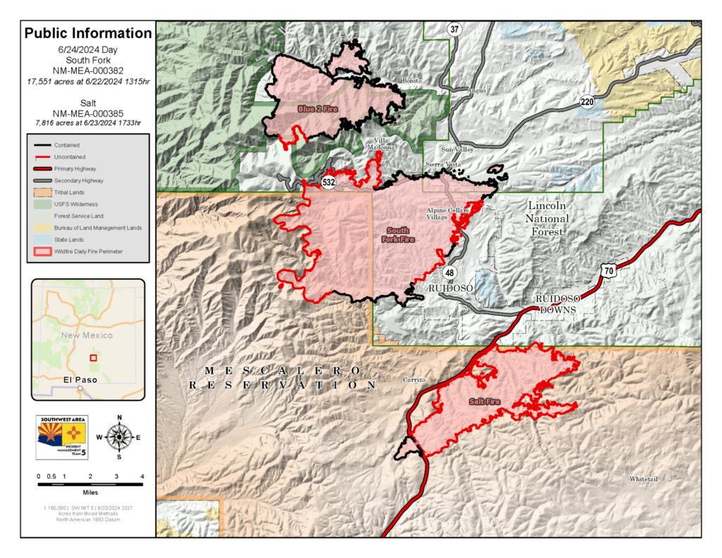
Triple wildfire threat: Blue 2, Salt, and South Fork Fires
According to sources on the ground, Lightning strikes started the Blue 2 Fire in the Gila National Forest on May 16, 2024. As of June 12, the fire had burned 7,532 acres and was 91% contained, according to the New Mexico Fire Information. The fire burned in steep and rugged terrain resulting in no damaged or destroyed structures, according to the Southwest Coordination Center.
The Salt Fire is located in the Lincoln National Forest, seven miles west of Mescalero, New Mexico. It has burned 7,816 acres and was only 7% contained as of June 24, according to the New Mexico Fire Information. Firefighters face extreme fire behavior and spotting as well as limited access and resources. The fire is burning in mixed conifer and ponderosa pine forests and threatens several communities, power lines, communication towers, and watersheds.
The South Fork Fire—the largest of the three fires—is located in the Santa Fe National Forest near Ruidoso. It has burned 17,551 acres and is 37% contained as of June 24, according to the New Mexico Fire Information website. Firefighters have been conducting burnout operations and constructing fire lines to secure the fire perimeter and protect values at risk, such as homes, campgrounds, and cultural resources.
Both the Salt and South Fork Fires have damaged and destroyed structures in the community of Ruidoso.
Burn tracks increase flood risks
According to the National Weather Service, severe weather bringing heavy rain began on June 20 and began hindering firefighting efforts almost immediately. A reported 2.5 inches of rain fell within a 30 minute period in some areas.
This intense rainfall caused floods and landslides in the burned areas, as well as areas downslope of burn scars. Wildfires burn vegetation, which decreases soil cohesion and limits the soil’s ability to absorb water resulting in decreased surface water infiltration rates. Flash flooding and landslides occur when rainfall rates exceed surface water infiltration rates.
Research from the U.S. Geological Survey (USGS) indicates that the frequency of post-wildfire landslides will increase, especially in fire-prone, mountainous states. There is a major event occurring once every 10 years. Climate change is partially responsible for this phenomenon. The wildfire season is expected to lengthen, especially in the southwestern U.S., and the rainy season will shorten but the storms will increase in frequency and intensity.
This change increases the likelihood of intense rain following a wildfire which creates a dangerous combination for those who reside in communities outside and downslope of wildfire-vulnerable areas.
Click here for the report in its entirety.
The post Thousands of New Mexico Properties at Risk From Wildfires first appeared on The MortgagePoint.


